-
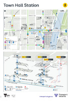 Town Hall Station [precinct map]
 A wayfinding poster of a metropolitan station and surrounding area. Includes two maps: a top down wayfinding map showing station exits, interchange to other transport modes, nearby landmarks with a 5 minute walk scale; and perspective map showing the interior of the station, including platforms and services, escalators, stairs, lifts and accessibility features.
-
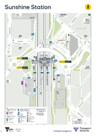 Sunshine Station [precinct map]
 A wayfinding poster of a metropolitan station and surrounding area. Includes a single map combining two elements: a top down wayfinding map showing station exits, interchange to other transport modes, nearby landmarks with a 5 minute walk scale; and perspective map showing the interior of the station, including platforms and services, escalators, stairs, lifts and accessibility features.
-
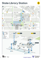 State Library Station [precinct map]
 A wayfinding poster of a metropolitan station and surrounding area. Includes two maps: a top down wayfinding map showing station exits, interchange to other transport modes, nearby landmarks with a 5 minute walk scale; and perspective map showing the interior of the station, including platforms and services, escalators, stairs, lifts and accessibility features.
-
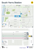 South Yarra Station [precinct map]
 A wayfinding poster of a metropolitan station and surrounding area. Includes two maps: a top down wayfinding map showing station exits, interchange to other transport modes, nearby landmarks with a 5 minute walk scale; and perspective map showing the interior of the station, including platforms and services, escalators, stairs, lifts and accessibility features.
-
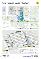 Southern Cross Station [precinct map]
 A wayfinding poster of a metropolitan station and surrounding area. Includes two maps: a top down wayfinding map showing station exits, interchange to other transport modes, nearby landmarks with a 5 minute walk scale; and perspective map showing the interior of the station, including platforms and services, escalators, stairs, lifts and accessibility features.
-
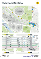 Richmond Station [precinct map]
 A wayfinding poster of a metropolitan station and surrounding area. Includes two maps: a top down wayfinding map showing station exits, interchange to other transport modes, nearby landmarks with a 5 minute walk scale; and perspective map showing the interior of the station, including platforms and services, escalators, stairs, lifts and accessibility features.
-
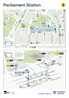 Parliament Station [precinct map]
 A wayfinding poster of a metropolitan station and surrounding area. Includes two maps: a top down wayfinding map showing station exits, interchange to other transport modes, nearby landmarks with a 5 minute walk scale; and perspective map showing the interior of the station, including platforms and services, escalators, stairs, lifts and accessibility features.
-
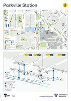 Parkville Station [precinct map]
 A wayfinding poster of a metropolitan station and surrounding area. Includes two maps: a top down wayfinding map showing station exits, interchange to other transport modes, nearby landmarks with a 5 minute walk scale; and perspective map showing the interior of the station, including platforms and services, escalators, stairs, lifts and accessibility features.
-
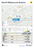 North Melbourne Station [precinct map]
 A wayfinding poster of a metropolitan station and surrounding area. Includes two maps: a top down wayfinding map showing station exits, interchange to other transport modes, nearby landmarks with a 5 minute walk scale; and perspective map showing the interior of the station, including platforms and services, escalators, stairs, lifts and accessibility features.
-
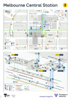 Melbourne Central Station [precinct map]
 A wayfinding poster of a metropolitan station and surrounding area. Includes two maps: a top down wayfinding map showing station exits, interchange to other transport modes, nearby landmarks with a 5 minute walk scale; and perspective map showing the interior of the station, including platforms and services, escalators, stairs, lifts and accessibility features.
-
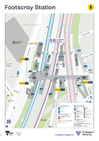 Footscray Station [precinct map]
 A wayfinding poster of a metropolitan station and surrounding area. Includes a single map combining two elements: a top down wayfinding map showing station exits, interchange to other transport modes, nearby landmarks with a 5 minute walk scale; and perspective map showing the interior of the station, including platforms and services, escalators, stairs, lifts and accessibility features.
-
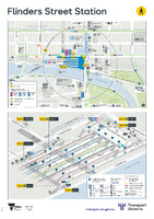 Flinders Street Station [precinct map]
 A wayfinding poster of a metropolitan station and surrounding area. Includes two maps: a top down wayfinding map showing station exits, interchange to other transport modes, nearby landmarks with a 5 minute walk scale; and perspective map showing the interior of the station, including platforms and services, escalators, stairs, lifts and accessibility features.
-
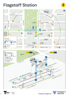 Flagstaff Station [precinct map]
 A wayfinding poster of a metropolitan station and surrounding area. Includes two maps: a top down wayfinding map showing station exits, interchange to other transport modes, nearby landmarks with a 5 minute walk scale; and perspective map showing the interior of the station, including platforms and services, escalators, stairs, lifts and accessibility features.
-
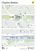 Clayton Station [precinct map]
 A wayfinding poster of a metropolitan station and surrounding area. Includes two maps: a top down wayfinding map showing station exits, interchange to other transport modes, nearby landmarks with a 5 minute walk scale; and perspective map showing the interior of the station, including platforms and services, escalators, stairs, lifts and accessibility features.
-
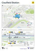 Caulfield Station [precinct map]
 A wayfinding poster of a metropolitan station and surrounding area. Includes two maps: a top down wayfinding map showing station exits, interchange to other transport modes, nearby landmarks with a 5 minute walk scale; and perspective map showing the interior of the station, including platforms and services, escalators, stairs, lifts and accessibility features.
-
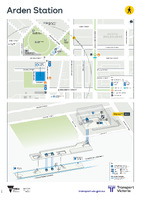 Arden Station [precinct map]
 A wayfinding poster of a metropolitan station and surrounding area. Includes two maps: a top down wayfinding map showing station exits, interchange to other transport modes, nearby landmarks with a 5 minute walk scale; and perspective map showing the interior of the station, including platforms and services, escalators, stairs, lifts and accessibility features.
-
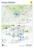 Anzac Station [precinct map]
 A wayfinding poster of a metropolitan station and surrounding area. Includes two maps: a top down wayfinding map showing station exits, interchange to other transport modes, nearby landmarks with a 5 minute walk scale; and perspective map showing the interior of the station, including platforms and services, escalators, stairs, lifts and accessibility features.