-
Your guide to concession fares
Brochure outlining different concessions and travel passes available for travelling using myki in Victoria. Includes information on the different concessions available, eligibility requirements and proof of eligibility required. Does not include fare specifics costs for each concession fare.
-
Ballarat Line fares 2026
Brochure outlining fares for the given line. Contains sections for myki Money and myki Pass, and for travelling in and out of Zone 1, and for travelling outside of Zone 1.
Also includes a schematic diagram of the given line indicating which zone each station belongs to.
Also include general myki information about fare duration, maximum daily fares and overlap zones.
-
Bendigo Line fares 2026
Brochure outlining fares for the given line. Contains sections for myki Money and myki Pass, and for travelling in and out of Zone 1, and for travelling outside of Zone 1.
Also includes a schematic diagram of the given line indicating which zone each station belongs to.
Also include general myki information about fare duration, maximum daily fares and overlap zones.
-
Seymour Line fares 2026
Brochure outlining fares for the given line. Contains sections for myki Money and myki Pass, and for travelling in and out of Zone 1, and for travelling outside of Zone 1.
Also includes a schematic diagram of the given line indicating which zone each station belongs to.
Also include general myki information about fare duration, maximum daily fares and overlap zones.
-
Geelong Line fares 2026
Brochure outlining fares for the given line. Contains sections for myki Money and myki Pass, and for travelling in and out of Zone 1, and for travelling outside of Zone 1.
Also includes a schematic diagram of the given line indicating which zone each station belongs to.
Also include general myki information about fare duration, maximum daily fares and overlap zones.
-
Gippsland Line fares 2026
Brochure outlining fares for the given line. Contains sections for myki Money and myki Pass, and for travelling in and out of Zone 1, and for travelling outside of Zone 1.
Also includes a schematic diagram of the given line indicating which zone each station belongs to.
Also include general myki information about fare duration, maximum daily fares and overlap zones.
-
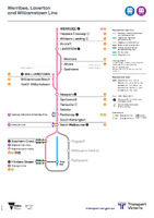 Werribee, Laverton and Williamstown Line [schematic linear diagram]
 A linear schematic diagram showing stations along a given railway line. The diagram specifically highlights tram and bus interchanges, other metropolitan rail interchanges, regional rail interchanges, designated interchange stations, and staffing of various stations.
The diagram also highlights the names of stations part of the "City Loop" and "Metro Tunnel".
-
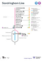 Sandringham Line [schematic linear diagram]
 A linear schematic diagram showing stations along a given railway line. The diagram specifically highlights tram and bus interchanges, other metropolitan rail interchanges, regional rail interchanges, designated interchange stations, and staffing of various stations.
The diagram also highlights the names of stations part of the "City Loop" and "Metro Tunnel".
-
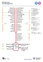 Mernda and Hurstbridge lines [schematic linear diagram]
 A linear schematic diagram showing stations along a given railway line. The diagram specifically highlights tram and bus interchanges, other metropolitan rail interchanges, regional rail interchanges, designated interchange stations, and staffing of various stations.
The diagram also highlights the names of stations part of the "City Loop" and "Metro Tunnel".
-
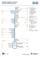 Lilydale, Belgrave, Alamein and Glen Waverley lines [schematic linear diagram]
 A linear schematic diagram showing stations along a given railway line. The diagram specifically highlights tram and bus interchanges, other metropolitan rail interchanges, regional rail interchanges, designated interchange stations, and staffing of various stations.
The diagram also highlights the names of stations part of the "City Loop" and "Metro Tunnel".
-
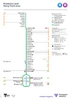 Frankston and Stony Point lines [schematic linear diagram]
 A linear schematic diagram showing stations along a given railway line. The diagram specifically highlights tram and bus interchanges, other metropolitan rail interchanges, regional rail interchanges, designated interchange stations, and staffing of various stations.
The diagram also highlights the names of stations part of the "City Loop" and "Metro Tunnel".
-
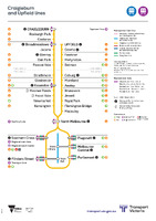 Craigieburn and Upfield lines [schematic linear diagram]
 A linear schematic diagram showing stations along a given railway line. The diagram specifically highlights tram and bus interchanges, other metropolitan rail interchanges, regional rail interchanges, designated interchange stations, and staffing of various stations.
The diagram also highlights the names of stations part of the "City Loop" and "Metro Tunnel".
-
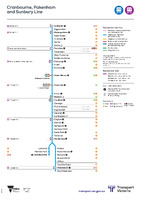 Cranbourne, Pakenham and Sunbury Line [schematic linear diagram]
 A linear schematic diagram showing stations along a given railway line. The diagram specifically highlights tram and bus interchanges, other metropolitan rail interchanges, regional rail interchanges, designated interchange stations, and staffing of various stations.
The diagram also highlights the names of stations part of the "City Loop" and "Metro Tunnel".