-
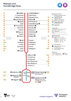 Mernda and Hurstbridge lines [schematic linear diagram]
 A linear schematic diagram showing stations along a given railway line. The diagram specifically highlights tram and bus interchanges, other metropolitan rail interchanges, regional rail interchanges, designated interchange stations, and staffing of various stations.
The diagram also highlights the names of stations part of the "City Loop" and "Metro Tunnel".
-
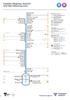 Lilydale, Belgrave, Alamein and Glen Waverley lines [schematic linear diagram]
 A linear schematic diagram showing stations along a given railway line. The diagram specifically highlights tram and bus interchanges, other metropolitan rail interchanges, regional rail interchanges, designated interchange stations, and staffing of various stations.
The diagram also highlights the names of stations part of the "City Loop" and "Metro Tunnel".
-
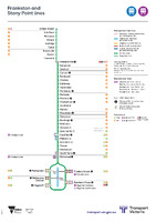 Frankston and Stony Point lines [schematic linear diagram]
 A linear schematic diagram showing stations along a given railway line. The diagram specifically highlights tram and bus interchanges, other metropolitan rail interchanges, regional rail interchanges, designated interchange stations, and staffing of various stations.
The diagram also highlights the names of stations part of the "City Loop" and "Metro Tunnel".
-
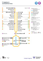 Craigieburn and Upfield lines [schematic linear diagram]
 A linear schematic diagram showing stations along a given railway line. The diagram specifically highlights tram and bus interchanges, other metropolitan rail interchanges, regional rail interchanges, designated interchange stations, and staffing of various stations.
The diagram also highlights the names of stations part of the "City Loop" and "Metro Tunnel".
-
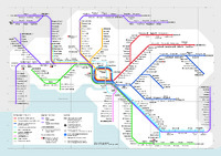 [Victorian rail network schematic diagram. Metro tunnel trial period]
-
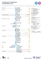 Cranbourne, Pakenham and Sunbury Line [schematic linear diagram]
 A linear schematic diagram showing stations along a given railway line. The diagram specifically highlights tram and bus interchanges, other metropolitan rail interchanges, regional rail interchanges, designated interchange stations, and staffing of various stations.
The diagram also highlights the names of stations part of the "City Loop" and "Metro Tunnel".
-
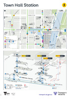 Town Hall Station [precinct map]
 A wayfinding poster of a metropolitan station and surrounding area. Includes two maps: a top down wayfinding map showing station exits, interchange to other transport modes, nearby landmarks with a 5 minute walk scale; and perspective map showing the interior of the station, including platforms and services, escalators, stairs, lifts and accessibility features.
-
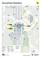 Sunshine Station [precinct map]
 A wayfinding poster of a metropolitan station and surrounding area. Includes a single map combining two elements: a top down wayfinding map showing station exits, interchange to other transport modes, nearby landmarks with a 5 minute walk scale; and perspective map showing the interior of the station, including platforms and services, escalators, stairs, lifts and accessibility features.
-
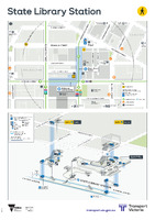 State Library Station [precinct map]
 A wayfinding poster of a metropolitan station and surrounding area. Includes two maps: a top down wayfinding map showing station exits, interchange to other transport modes, nearby landmarks with a 5 minute walk scale; and perspective map showing the interior of the station, including platforms and services, escalators, stairs, lifts and accessibility features.
-
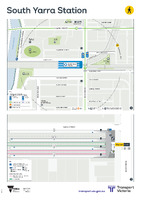 South Yarra Station [precinct map]
 A wayfinding poster of a metropolitan station and surrounding area. Includes two maps: a top down wayfinding map showing station exits, interchange to other transport modes, nearby landmarks with a 5 minute walk scale; and perspective map showing the interior of the station, including platforms and services, escalators, stairs, lifts and accessibility features.
-
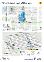 Southern Cross Station [precinct map]
 A wayfinding poster of a metropolitan station and surrounding area. Includes two maps: a top down wayfinding map showing station exits, interchange to other transport modes, nearby landmarks with a 5 minute walk scale; and perspective map showing the interior of the station, including platforms and services, escalators, stairs, lifts and accessibility features.
-
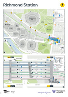 Richmond Station [precinct map]
 A wayfinding poster of a metropolitan station and surrounding area. Includes two maps: a top down wayfinding map showing station exits, interchange to other transport modes, nearby landmarks with a 5 minute walk scale; and perspective map showing the interior of the station, including platforms and services, escalators, stairs, lifts and accessibility features.
-
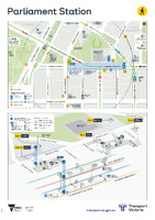 Parliament Station [precinct map]
 A wayfinding poster of a metropolitan station and surrounding area. Includes two maps: a top down wayfinding map showing station exits, interchange to other transport modes, nearby landmarks with a 5 minute walk scale; and perspective map showing the interior of the station, including platforms and services, escalators, stairs, lifts and accessibility features.
-
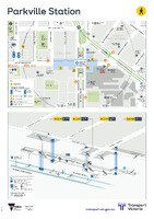 Parkville Station [precinct map]
 A wayfinding poster of a metropolitan station and surrounding area. Includes two maps: a top down wayfinding map showing station exits, interchange to other transport modes, nearby landmarks with a 5 minute walk scale; and perspective map showing the interior of the station, including platforms and services, escalators, stairs, lifts and accessibility features.
-
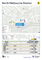 North Melbourne Station [precinct map]
 A wayfinding poster of a metropolitan station and surrounding area. Includes two maps: a top down wayfinding map showing station exits, interchange to other transport modes, nearby landmarks with a 5 minute walk scale; and perspective map showing the interior of the station, including platforms and services, escalators, stairs, lifts and accessibility features.
-
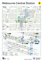 Melbourne Central Station [precinct map]
 A wayfinding poster of a metropolitan station and surrounding area. Includes two maps: a top down wayfinding map showing station exits, interchange to other transport modes, nearby landmarks with a 5 minute walk scale; and perspective map showing the interior of the station, including platforms and services, escalators, stairs, lifts and accessibility features.
-
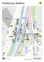 Footscray Station [precinct map]
 A wayfinding poster of a metropolitan station and surrounding area. Includes a single map combining two elements: a top down wayfinding map showing station exits, interchange to other transport modes, nearby landmarks with a 5 minute walk scale; and perspective map showing the interior of the station, including platforms and services, escalators, stairs, lifts and accessibility features.
-
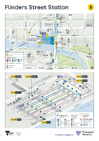 Flinders Street Station [precinct map]
 A wayfinding poster of a metropolitan station and surrounding area. Includes two maps: a top down wayfinding map showing station exits, interchange to other transport modes, nearby landmarks with a 5 minute walk scale; and perspective map showing the interior of the station, including platforms and services, escalators, stairs, lifts and accessibility features.
-
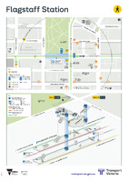 Flagstaff Station [precinct map]
 A wayfinding poster of a metropolitan station and surrounding area. Includes two maps: a top down wayfinding map showing station exits, interchange to other transport modes, nearby landmarks with a 5 minute walk scale; and perspective map showing the interior of the station, including platforms and services, escalators, stairs, lifts and accessibility features.
-
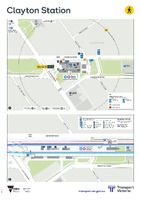 Clayton Station [precinct map]
 A wayfinding poster of a metropolitan station and surrounding area. Includes two maps: a top down wayfinding map showing station exits, interchange to other transport modes, nearby landmarks with a 5 minute walk scale; and perspective map showing the interior of the station, including platforms and services, escalators, stairs, lifts and accessibility features.
-
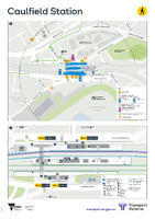 Caulfield Station [precinct map]
 A wayfinding poster of a metropolitan station and surrounding area. Includes two maps: a top down wayfinding map showing station exits, interchange to other transport modes, nearby landmarks with a 5 minute walk scale; and perspective map showing the interior of the station, including platforms and services, escalators, stairs, lifts and accessibility features.
-
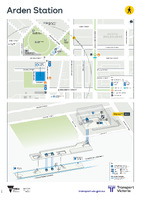 Arden Station [precinct map]
 A wayfinding poster of a metropolitan station and surrounding area. Includes two maps: a top down wayfinding map showing station exits, interchange to other transport modes, nearby landmarks with a 5 minute walk scale; and perspective map showing the interior of the station, including platforms and services, escalators, stairs, lifts and accessibility features.
-
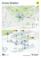 Anzac Station [precinct map]
 A wayfinding poster of a metropolitan station and surrounding area. Includes two maps: a top down wayfinding map showing station exits, interchange to other transport modes, nearby landmarks with a 5 minute walk scale; and perspective map showing the interior of the station, including platforms and services, escalators, stairs, lifts and accessibility features.