Clayton Station [precinct map]
Item
-
Constructed Title
-
Clayton Station [precinct map]
-
Type
-
Wayfinding map
-
Creator
-
Transport Victoria [Victoria. Department of Transport and Planning]
-
Date Created
-
22 January 2026
-
Description
-
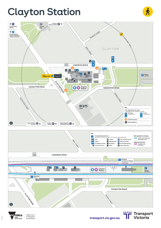
A wayfinding poster of a metropolitan station and surrounding area. Includes two maps: a top down wayfinding map showing station exits, interchange to other transport modes, nearby landmarks with a 5 minute walk scale; and perspective map showing the interior of the station, including platforms and services, escalators, stairs, lifts and accessibility features.
-
Format
-
A1 poster
-
application/pdf
-
Language
-
en-AU
-
Publisher
-
Transport Victoria [Victoria. Department of Transport and Planning]
-
Extent
-
Single A1 poster
-
Identifier
-
local:dtp:DTP0891/25-A
-
Subject
-
Railroads -- Victoria -- Melbourne Metropolitan Area -- Wayfinding
-
Public transport -- Victoria
-
Classification
-
ddc:385.095945
-
udc:656.2(945.1)(084.3)
-
Provenance
-
Digital copy obtained by AW from transport.vic.gov.au, March 2026.
-
Digital original
 Digital original PDF